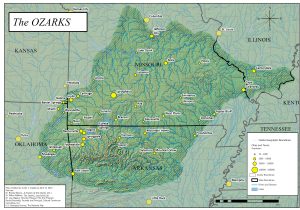
New Map of the Ozarks Region
 Many good things came out of the Ozarks Program recently held on the National Mall in DC as part of the annual Smithsonian Folklife Festival. One of them was a new map of the Ozarks.
The planning committee for the Ozarks Program wanted to create a new map of the region specifically for this Festival program, and we commissioned Curtis Copeland to work with the committee on the design and details. Copeland is a GIS Manager for the City of Branson, and he was instrumental in the revitalization of the Society of Ozarkian Hillcrofters. The Ozarks Studies Institute, an ongoing initiative of the Missouri State University Libraries, paid Copeland to design and fine-tune the new map.
The boundaries of the Ozark region always have been open to debate and discussion. Most previous maps of the Ozarks tended to use bold, solid lines as a border for the region. The new map uses a hashed line to indicate that the boundaries are a bit murky and fluid.
The southern boundary of the multi-state region had bothered several members of the planning committee for years. Rachel Reynolds took it upon herself to drive along the southern boundary of the Ozarks and try to establish a more defensible southern border.
The biggest difference between the new map and other maps of the region, however, is the inclusion of portions of southern Illinois as part of the Ozarks region. This has generated some lively discussion on social media.
A large printed version of the map was brought back from DC and is on display in the Ozarks Room on the Third Level of Duane G. Meyer Library on the main Springfield campus of Missouri State University.