All Sanborn Maps Online by 2020
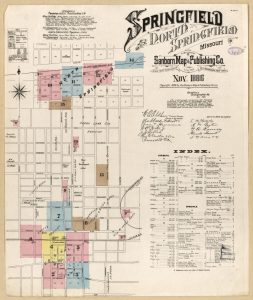 The Library of Congress recently announced that all Sanborn Fire Insurance Maps, dating from the late 19th and early 20th centuries, will be digitized and freely available online by the year 2020. 25,000 already are available online, with 500,000 slated to be freely available online by 2020. Sanborn maps depict the location, size, and building materials used for all buildings in a city at the time the map was made. Sanborn maps are useful to historians, urban planners, genealogists, students, and others (including insurance companies, of course). The University of Missouri already has digitized and made available online various Sanborn maps for many Missouri locations, including Springfield.